Military Airfields in WW2
1941-1945
Current total: 2,308
Latest update:
11/19/2011 update
Copyrighted 2005-2012
David W. Brooks
WW2 Airfields and seaplane bases by state:
![]()
R26c1 - 01/01/2011
![]()
R27b - 09/10/2011
![]()
R27e - 11/19/2011
![]()
R27a - 09/21/2011
![]()
R27c - 6/02/2011
![]()
R2 - 5/20/2009
Additional data:
![]()
![]()
Many thanks to Brian Rehwinkel who has answered one of those open questions we had. Identifying the OLFs used by NAS Hutchinson, KS. His data identified 20 OLFs of which only 2 had been identified. He was kind enough to share three photos taken in 1943 by the USN for OLF's No. 11, 15 and 16.
Two previously unknown airfields have come to light thanks to Jim Heringer. The two airfields are located on the Hanford facilities which started in WW2 to support the Manhattan Project (the project to develop the Atomic Bomb). There may have been or or two other airstrips at Hanford but no data has been firm enough to be added to the data base at t his time.
AL-CA - typo errors fixed.
Location determined for Danville AF Aux No. 1 to Courtland AAF in Alabama (thanks to John Simms).
Minor update in CO-HA section on Avon Park AAF.
Added on Army airfield in Helena MT and some additional pictures of Lake Charles AAF.
A minor correction in the Arizona section for Marana's auxiliary airfields.
TX-WY section upgraded to R27a. Additional pictures of some of the OLFs for NAS Corpus Christi have been added thanks to Mr. Brian Rehwinkel for the photos.
Two databases have been upgraded to R27. Updated pictures and two airfields added in Hawaii section. New updated pictures have been added to the Texas database. This covers new early photographs for most of the OLFs associated with NAS Corpus Christi and a few other airfields in Texas. Other databases have not been updated yet.
Release R26 adds many new pictures. Various updates in all sections have been made. The Texas-Wyoming has been fully updated as other sections were during the update cycle.
Additional sections will be updated in the near future. Many of the photographs added are from the 1945 AAF Directory of airfields/airports in the Continental U.S. The quality of these photographs are not real good as they are taken from a .pdf file which was not scanned at high resolution.
Release 25 adds some more pictures and a few minor updates (some better coordinates on a few small fields).
This is the release of version R24 of the World War II data base. A large amount of the data has been enhanced and additional pictures have been added. An additional 38 airfields have been found and added to the data base. These were auxiliary airfields used by "parent" bases.
This release is part 1 of two major planned releases. The second part will include a lot of additional photos taken during the war of airfields. Some of the pictures are currently in the data base, but are of poor quality. The plan is to replace poor quality photos and add photos. The exact date is not set, but likely in two or three months hence.
This is release R23 of the World War II data base. Additional photographs have been added and bad links fixed (I hope!). Those photographs that are identified as "1945 AAF" unfortunately, the quality of many of these photographs are poor as the source was from microfilm, to paper using a microfilm reader and then scanned into computer format. Thus significant degradation to the quality of the images resulted. This is still very much a work-in-progress as much more research into these documents is required.
From these early documents, the Military made use of a number of CAA Intermediate sites. Some have been incorporated into the data base. However, you can look at the CAA Intermediate Sites data base for complete listing of all known CAA/FAA Intermediate sites in the continental United States (CONUS).
Virtually all Flight Strips were used by the Military (Army, AAF, Navy and Marines) during the war. Some are in the main data base, but the complete data base for all Flight Strips is available on this page. Click on the green Flight Strips.
Some terms used had earlier versions. Example for the AAF was the use of Contract Pilot Schools (CPS). In the 1941 through part of 1943, these were also referred to as Contract Flying Schools (CFS). See the bottom of this page for more on Contract schools and the CAA's Civil Pilot Training Program (CPTP).
The AAF Base Structure and the Navy-Marines Structure listings are not up-to-date. These represent the state of airfields and auxiliaries (OLFs too) from Dec. 1944 till the end of the war.
FORMAT INFORMATION:
The data has been reorganized to hopefully be easier to follow. Information is still organized by states listed alphabetically. Major bases (either AAF or Navy/Marines) or other major facilities are still in the first column. Those major bases that had auxiliary, satellite and sub-base are indented 1 place. Bases that have airfields reporting to them are also bolded. This reorganization should help to understand the relationship between auxiliaries and main bases.
Auxiliary airfields for the AAF and Out Lying Fields (OLF) for the Navy/Marines are indented 2 places.
This is just an example:
Luke AAF (main base)
Luke Aux. No. 1 (auxiliary)
Luke Aux. No. 2 (auxiliary)
Ajo AAF (sub-base)
Auxiliary No. 1 (auxiliary)
Auxiliary No. 2 (auxiliary)
Gila Bend AAF Aux (sub-base)
Auxiliary No. 1 (auxiliary)
Auxiliary No. 2 (auxiliary)
Corpus Christi NAS (main base)
OLF #41 (OLF auxiliary)
Kingsville North NAAS (Auxiliary to NAS Corpus Christi)
Kingsville South NAAS (Auxiliary to NAS Corpus Christi)
OLF #42 (OLF auxiliary)
OLF #55 (OLF auxiliary)
Rodd NAAS (Auxiliary to NAS Corpus Christi)
OLF #1C (OLF auxiliary)
OLF #12 (OLF auxiliary)
The rest of the data is still there. Items with photographs are blue and underscored hyperlinks.
There are cases where auxiliaries may not be in the same state as the main base is located. These auxiliaries are still located in the state where they are located. In the comment column, the location is bolded. Example the main base is located in FL for Florida. Hopefully this is not confusing, but was the only method that seems to work with the data base.
There are major bases that had not auxiliaries and does not diminish there importance.
One other change has been with this release. All latitude coordinates are north and thus no other annotation is made. All longitude coordinates are west and the change is in the representation of the decimal coordinates now have a negative (-) symbol in front of them representing west. In the future, Alaska will be added and there are a few bases that were located in the eastern hemisphere. This change is made in advance so when Alaska section is added, there will be no conflict with standard notation for longitudinal coordinates.
I wish to extend my thanks and appreciation to Mr. Brian Rehwinkel and Mr. Chris Kennedy for there help.
(See the bottom of the home page for info about picture sources.)
INTRODUCTION
The information gathered is an attempt to list all known airfields used during WW2 (1941-1945). The data contained in this data base covers the 48 contiguous states and now Alaska and Hawaii are included. This includes Army, AAF, Navy, Marines, Coast Guard and a few of the Civil Air Patrol (CAP) airfields and seaplane bases. A variety of sources have been used to create this data base.
Directories, charts, maps, Government and historical data has been used in creating this data base. During WW2, many civil and auxiliary airfields (civil or private), were used by the military. Identification of all of these airfields is limited by available data. Some of the airfields in this data base are listed as having "joint" usage. Joint operation could mean AAF and Navy or civil operations in addition to military usage. These were civil/commercial, auxiliary and private airfields continued there normal business as well as handling military operations. I have also endeavored to verify the location coordinates, but some are just not available due to lack of information.
The Army Air Forces referred to there major air facilities as Army Air Field (AAF). There were some Army Air Forces major facilities referred to as Army Air Base (AAB). The Army Air Forces referred to its auxiliary airfields as auxiliaries. Generally the designation of Auxiliary Air Field Number (AF Aux No. has been used in this data base) and/or name. Normally, the AAF numbered the auxiliary airfields. Often, a name was given or adopted too in addition to the number.
The Navy and Marines referred to the major facilities as Naval Air Station (NAS) or Naval Air Facility (NAF) and Marine Corps Air Station (MCAS). The next tier down was a Naval Auxiliary Air Station (NAAS) or Naval Auxiliary Air Facility (NAAF) and Marine Corps Auxiliary Air Station (MCAAS). Support airfields were referred to as Out Lying Field (OLF). Normally, the Navy and Marines named there OLFs. The Navy also had a number system that was associated with the property referred to as Naval Air Facility (NAF). An example of this form of identification is NAF-12345. Fields identified by these numbers (a lot of charts showed OLFs this way) also had names. Most of the names have been determined. Just for confusion, many of the OLFs associated with Corpus Christi's NAS used "names" which were numbers too! (e.g. NAF 25519 - OLF No. 2B). Have not been able to locate all of the OLF names associated with Clinton NAS in Oklahoma and Hutchinson NAS in Kansas.
To the best of my knowledge and research, all major facilities have been identified. As I have researched this information, it has become apparent that many (but not all) AAF auxiliary fields or NAS Out Lying Fields (OLFs) have been identified. The area where data is weak deals with the auxiliary airfields used by "major" air facility (an AAF / AAB for the AAF, NAS / NAAS for the Navy and MCAS / MCAAS for the Marines. Another area where data has been difficult to find is the auxiliaries used by contractor training from there home bases. There are a few airfields identified in the data base that were used by the Army and Coast Guard but these did not seem to have any auxiliaries.
The issue is that not all of the auxiliary fields/OLFs have been accounted for. Using the AAF process as an example, you could have Wonderful AAF with auxiliaries:
Wonderful AAF
#1 – Aux Fld.
#2 – Aux Fld.
#4 – Aux Fld.
#6 – Aux Fld.
Two numbers are unaccounted for – number 3 and 5. Until identified in documentation, I treat this situation with the following possibilities.
Planned for but nothing was done.
Planned for and land was acquired but halted (or used for something else such as bombing and/or gunnery range).
Planned for, land acquired and used - but the information has become lost in time. (This principally applies to auxiliary airfields that were turf/dirt in nature with minimum infrastructure support elements placed at the field.)
Planned for and used an existing civil/commercial/auxiliary airports or CAA intermediate airfields but the data has become lost in time.
Some AAF auxiliaries were used by more than one AAF. Where known, information has been placed in the comments column of the data base.
These auxiliary (or OLF for the Navy and Marines) often were farm type fields that were used. The field would be mowed, cleared of brush, the land rolled or leveled a bit. These fields were always close to a road for logistics support. Some auxiliary fields had more extensive facilities including paved runways. The AAF often used the "triangle" layout. The Navy used several patterns including what I call offset squares. However, other layout patterns were used. One thing I have noticed is that some layouts are "regional" in usage. That is, the "triangle" layout is more common in selected western states (AZ, CA, CO, NM and TX).
Sometimes, this offset squares was referred to as "eight star" layout. These seemed to vary from about 1,200 feet to as large as about 2,000 feet. There was at least one occasion where the pattern was not completed and the OLF was referred to as "Five Point" (an OLF supporting NAS Hensley in Dallas, TX). Even though the octagonal pad was used at some OLFs, in looking for old OLFs, there is a possibility of wrong identification as to layout may have taken place as the interior of the squares often looks a bit like octagonal layout. (The drawing to the has one layer shaded differently for easier understanding.)
The octagonal layout was used and many of these were paved (including concrete as well as asphalt) and a few may have used steel matting material. Remains of some of these exist today.
The AAF often used the "triangle" type layout with two, three or four runways. There are examples where this layout had various runway lengths from 3,500 feet up to over 5,000 feet. Sometimes the center or bisecting runway was narrow and used as a taxi way. A small ramp might be along one of the sides of the triangle. These were routinely paved and many examples of this layout are still seen and some act as local airports to the near by communities. There are also many variations on the triangle layout.
With the current update, pictures have been added. One thing to keep in mind, some of the airfields that are still active generally have undergone changes. Runways eliminated, lengthened, rearranged and completely revamped. The latter is particularly true for those airfields that are today major civil airports (e.g. Chicago's O'Hara - ORD).
CAA's Civilian Pilot Training Program
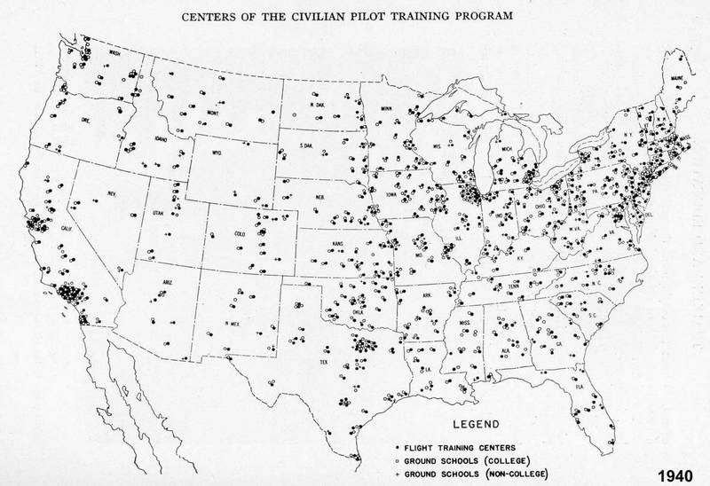
To understand the role played by civil/private training of pilots played, one has to look back to the Civil Aeronautics Authority (CAA) program referred to as the Civilian Pilot Training Program (CPTP). This effort was launched in 1939 by the CAA with some 13 "colleges" and by 1940 over 300 schools were involved across the USA. The figure below is a map in the 1941 Aircraft Year Book and shows the distribution of CPTP locations by late 1940.
In addition to civilians taking part in the CPTP, the Army Air Corps and Navy were involved. The CAA CPTP program was deemed superior to that used by the Army or the Navy. Training with light airplanes rather than heaver trainers was was much more productive. With the start of the war, the CAA's CPTP ceased to exist and was changed to War Training Service (WTS) and often referred to as CPTP-WTS. Often where the Navy used a CPTP - the documentation would list it as CPTP-WTS.
At this point, a split between the Army and Navy training took place with regards to contract training. The AAF continued to make heavy use of the CPTP program but the AAF directly took over the contracts and initially referred to these as Contract Flying Schools (CFS) and later as Contract Pilot School (CPS). Some additional training centers were added, but the majority of the AAF CPS centers came from the CPTP. There was some friction between the CAA and AAF as to how this was handled.
The Navy continued to use the CAA CPTP-WTS program till about mid 1943 by which time the Navy had its own primary training system fully developed. During this time, the Navy did not take over the CAA's contract, but rather continued to cooperate with the CAA.
The data base contains most known AAF-CPS and a few that the Navy used based on the CPTP. The data base will list a airport/airfield and the usage as Navy. Comments indicated that Navy usage is TBD. In my opinion, the vast majority of these were CPTP-WTS providing primary training to Navy cadets.
In order to accommodate a large training load, many of these AAF - CPS training centers needed additional airfields to support there work from there home base (field). These auxiliary airfields have not been, in most cases, well documented. Based on research in the AAF accident/crash report data base, numerous auxiliary airfields have been identified.